Australia FactbookDraft
November 2026 Edition
Australia Factbook · National chapter / AUS
Geography

ⓘ
2021 Factbook flag mirror; image identity has not been individually audited. Source.
Last updated: October 29, 2026
Map image could not be loaded. Open source image.
ⓘ
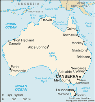
CIA World Factbook map, February 2021 media edition. Identity reviewed; current boundaries have not been audited. visual contact sheet or original identity check; does not verify current boundaries Boundaries, place names and designations may be dated or disputed; original annotations retained. SHA-256: 673b3825b1dd592ad9899a16d1d5aa5ddbef16a23acb60363d08a2b2608cb688. Provenance and inspection record.ⓘ
World Bank directory coordinates; approximate location, not a country center. Coordinate reference date is not supplied by the directory. Natural Earth 1:110m land (2022 source); simplified coastline, no political borders. Map source. Land SVG SHA-256: CF26056A39DC0A5B02F65704E279DFA86E77539A8387D0B2C92F907A67739E5E.Sections in Geography
- Location
- Geographic coordinates
- Map references
- Area
- Area - comparative
- Land boundaries
- Coastline
- Maritime claims
- Climate
- Terrain
- Elevation
- Natural resources
- Land use
- Irrigated land
- Major lakes (area sq km)
- Major rivers (by length in km)
- Major watersheds (area sq km)
- Major aquifers
- Population distribution
- Natural hazards
- Geography - note
Geography
Location:2
Oceania, continent between the Indian Ocean and the South Pacific Ocean
Geographic coordinates:3
27 00 S, 133 00 E
Map references:4
Oceania
Area:5
Surface area: 7,741,220 square kilometers (2024)
Area - comparative:7
slightly smaller than the 48 contiguous US states
Land boundaries:8
total:0 km
Coastline:9
25,760 km
Maritime claims:10
Climate:11
generally arid to semiarid; temperate in south and east; tropical in north
Terrain:12
mostly low plateau with deserts; fertile plain in southeast
Elevation:13
Natural resources:14
alumina, coal, iron ore, copper, lithium, tin, gold, silver, uranium, nickel, tungsten, rare earth elements, mineral sands, lead, zinc, diamonds, opals, natural gas, petroleum
note 1:Australia is the world's largest net exporter of coal accounting for 26.5% of global coal exports in 2021; coal is the country’s most abundant energy resource, and coal ranks as the second-largest export commodity from Australia in terms of revenue; in 2020, Australia held the third-largest recoverable coal reserves in the world behind the United States and Russia
note 2:Australia is by far the world's largest supplier of opals
note 3:Australia holds the largest uranium reserves in the world and was the second-largest global uranium producer behind Kazakhstan in 2020
note 4:Australia was the largest exporter of LNG in the world in 2020
Land use:15
agricultural land:47.2% (2023 est.)
arable land:4% (2023 est.)
permanent crops:0.1% (2023 est.)
permanent pasture:43.1% (2023 est.)
forest:17.3% (2023 est.)
other:35.4% (2023 est.)
Irrigated land:16
Major lakes (area sq km):17
Major rivers (by length in km):18
River Murray - 2,508 km; Darling River - 1,545 km; Murrumbidgee River - 1,485 km; Lachlan River - 1,339 km; Cooper Creek - 1,113 km; Flinders River - 1,004 km
Major watersheds (area sq km):19
Major aquifers:20
Great Artesian Basin, Canning Basin
Population distribution:21
population is primarily located on the periphery, with the highest concentration of people residing in the east and southeast; a secondary population center is located in and around Perth in the west; of the states and territories, New South Wales has, by far, the largest population; the interior, or "outback," has a very sparse population
Natural hazards:22
Geography - note:23
note 1:world's smallest continent but sixth-largest country; the largest country in Oceania, the largest country entirely in the Southern Hemisphere, and the largest country without land borders
note 2:the Great Dividing Range that runs along eastern Australia is that continent’s longest mountain range and the third-longest land-based range in the world; the term "Great Dividing Range" refers to the fact that the mountains form a watershed crest from which all of the rivers of eastern Australia flow – east, west, north, and south
note 3:Australia is the only continent without glaciers; it is the driest inhabited continent on earth; Perth on the west coast is home to the invigorating sea breeze known as the "Fremantle Doctor," one of the most consistent winds in the world; Australia hosts 10% of the world's biodiversity, and a great number of its flora and fauna exist nowhere else in the world
Notes & sources
- Location. Reference edition; observation: dates as stated in text. Field last updated: not supplied; profile fallback: 2025-12-04 09:22:13 -0500 (not a field revision date); needs review. Reference source. Edition retrieval date: not supplied (retrieval only). ↩
- Geographic coordinates. Reference edition; observation: dates as stated in text. Field last updated: not supplied; profile fallback: 2025-12-04 09:22:13 -0500 (not a field revision date); needs review. Reference source. Edition retrieval date: not supplied (retrieval only). ↩
- Map references. Reference edition; observation: dates as stated in text. Field last updated: not supplied; profile fallback: 2025-12-04 09:22:13 -0500 (not a field revision date); needs review. Reference source. Edition retrieval date: not supplied (retrieval only). ↩
- Area. Reference edition; observation: dates as stated in text. Field last updated: not supplied; profile fallback: 2025-12-04 09:22:13 -0500 (not a field revision date); needs review. Reference source. The archived total area has no reference year and territorial coverage may differ from World Bank surface area. World Bank: 7,741,220 square kilometers (2024). Reference: 7,741,220 square kilometers. Edition retrieval date: not supplied (retrieval only). ↩
- Surface area. Surface area: observation 2024; checked 2026-10-29; single source. World Bank World Development Indicators. The archived total area has no reference year and territorial coverage may differ from World Bank surface area. World Bank: 7,741,220 square kilometers (2024). Reference: 7,741,220 square kilometers. ↩
- Area - comparative. Reference edition; observation: dates as stated in text. Field last updated: not supplied; profile fallback: 2025-12-04 09:22:13 -0500 (not a field revision date); needs review. Reference source. Edition retrieval date: not supplied (retrieval only). ↩
- Land boundaries. Reference edition; observation: dates as stated in text. Field last updated: not supplied; profile fallback: 2025-12-04 09:22:13 -0500 (not a field revision date); needs review. Reference source. Edition retrieval date: not supplied (retrieval only). ↩
- Coastline. Reference edition; observation: dates as stated in text. Field last updated: not supplied; profile fallback: 2025-12-04 09:22:13 -0500 (not a field revision date); needs review. Reference source. Edition retrieval date: not supplied (retrieval only). ↩
- Maritime claims. Reference edition; observation: dates as stated in text. Field last updated: not supplied; profile fallback: 2025-12-04 09:22:13 -0500 (not a field revision date); needs review. Reference source. Edition retrieval date: not supplied (retrieval only). ↩
- Climate. Reference edition; observation: dates as stated in text. Field last updated: not supplied; profile fallback: 2025-12-04 09:22:13 -0500 (not a field revision date); needs review. Reference source. Edition retrieval date: not supplied (retrieval only). ↩
- Terrain. Reference edition; observation: dates as stated in text. Field last updated: not supplied; profile fallback: 2025-12-04 09:22:13 -0500 (not a field revision date); needs review. Reference source. Edition retrieval date: not supplied (retrieval only). ↩
- Elevation. Reference edition; observation: dates as stated in text. Field last updated: not supplied; profile fallback: 2025-12-04 09:22:13 -0500 (not a field revision date); needs review. Reference source. Edition retrieval date: not supplied (retrieval only). ↩
- Natural resources. Reference edition; observation: dates as stated in text. Field last updated: not supplied; profile fallback: 2025-12-04 09:22:13 -0500 (not a field revision date); needs review. Reference source. Edition retrieval date: not supplied (retrieval only). ↩
- Land use. Reference edition; observation: dates as stated in text. Field last updated: not supplied; profile fallback: 2025-12-04 09:22:13 -0500 (not a field revision date); needs review. Reference source. Edition retrieval date: not supplied (retrieval only). ↩
- Irrigated land. Reference edition; observation: 2022. Field last updated: not supplied; profile fallback: 2025-12-04 09:22:13 -0500 (not a field revision date); needs review. Reference source. Edition retrieval date: not supplied (retrieval only). ↩
- Major lakes (area sq km). Reference edition; observation: dates as stated in text. Field last updated: not supplied; profile fallback: 2025-12-04 09:22:13 -0500 (not a field revision date); needs review. Reference source. Edition retrieval date: not supplied (retrieval only). ↩
- Major rivers (by length in km). Reference edition; observation: dates as stated in text. Field last updated: not supplied; profile fallback: 2025-12-04 09:22:13 -0500 (not a field revision date); needs review. Reference source. Edition retrieval date: not supplied (retrieval only). ↩
- Major watersheds (area sq km). Reference edition; observation: dates as stated in text. Field last updated: not supplied; profile fallback: 2025-12-04 09:22:13 -0500 (not a field revision date); needs review. Reference source. Edition retrieval date: not supplied (retrieval only). ↩
- Major aquifers. Reference edition; observation: dates as stated in text. Field last updated: not supplied; profile fallback: 2025-12-04 09:22:13 -0500 (not a field revision date); needs review. Reference source. Edition retrieval date: not supplied (retrieval only). ↩
- Population distribution. Reference edition; observation: dates as stated in text. Field last updated: not supplied; profile fallback: 2025-12-04 09:22:13 -0500 (not a field revision date); needs review. Reference source. Edition retrieval date: not supplied (retrieval only). ↩
- Natural hazards. Reference edition; observation: dates as stated in text. Field last updated: not supplied; profile fallback: 2025-12-04 09:22:13 -0500 (not a field revision date); needs review. Reference source. Edition retrieval date: not supplied (retrieval only). ↩
- Geography - note. Reference edition; observation: dates as stated in text. Field last updated: not supplied; profile fallback: 2025-12-04 09:22:13 -0500 (not a field revision date); needs review. Reference source. Edition retrieval date: not supplied (retrieval only). ↩